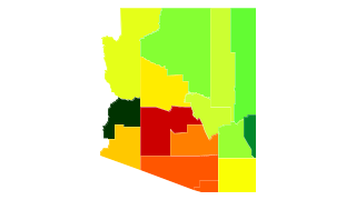
Arizona Population Density
Arizona Population Density Map
Arizona Population Density by County
| County | Population Density (Population/km2) | Population | Area (km2) |
|---|---|---|---|
| Maricopa County | 168 | 4,009,412 | 23,887 |
| Pima County | 42 | 996,554 | 23,808 |
| Pinal County | 28 | 389,350 | 13,930 |
| Santa Cruz County | 14 | 46,768 | 3,232 |
| Yuma County | 14 | 201,201 | 14,337 |
| Yavapai County | 10 | 215,133 | 21,079 |
| Cochise County | 8.0 | 129,473 | 16,087 |
| Mohave County | 5.8 | 203,030 | 34,895 |
| Gila County | 4.3 | 53,053 | 12,386 |
| Navajo County | 4.1 | 107,322 | 25,892 |
| Graham County | 3.1 | 37,482 | 12,055 |
| Coconino County | 2.8 | 136,539 | 48,334 |
| Apache County | 2.5 | 71,934 | 29,025 |
| Greenlee County | 1.9 | 9,049 | 4,785 |
| La Paz County | 1.7 | 20,324 | 11,682 |
Comments
© 2018 AtlasBig.com
