Iowa Population Density
Iowa Population Density Map
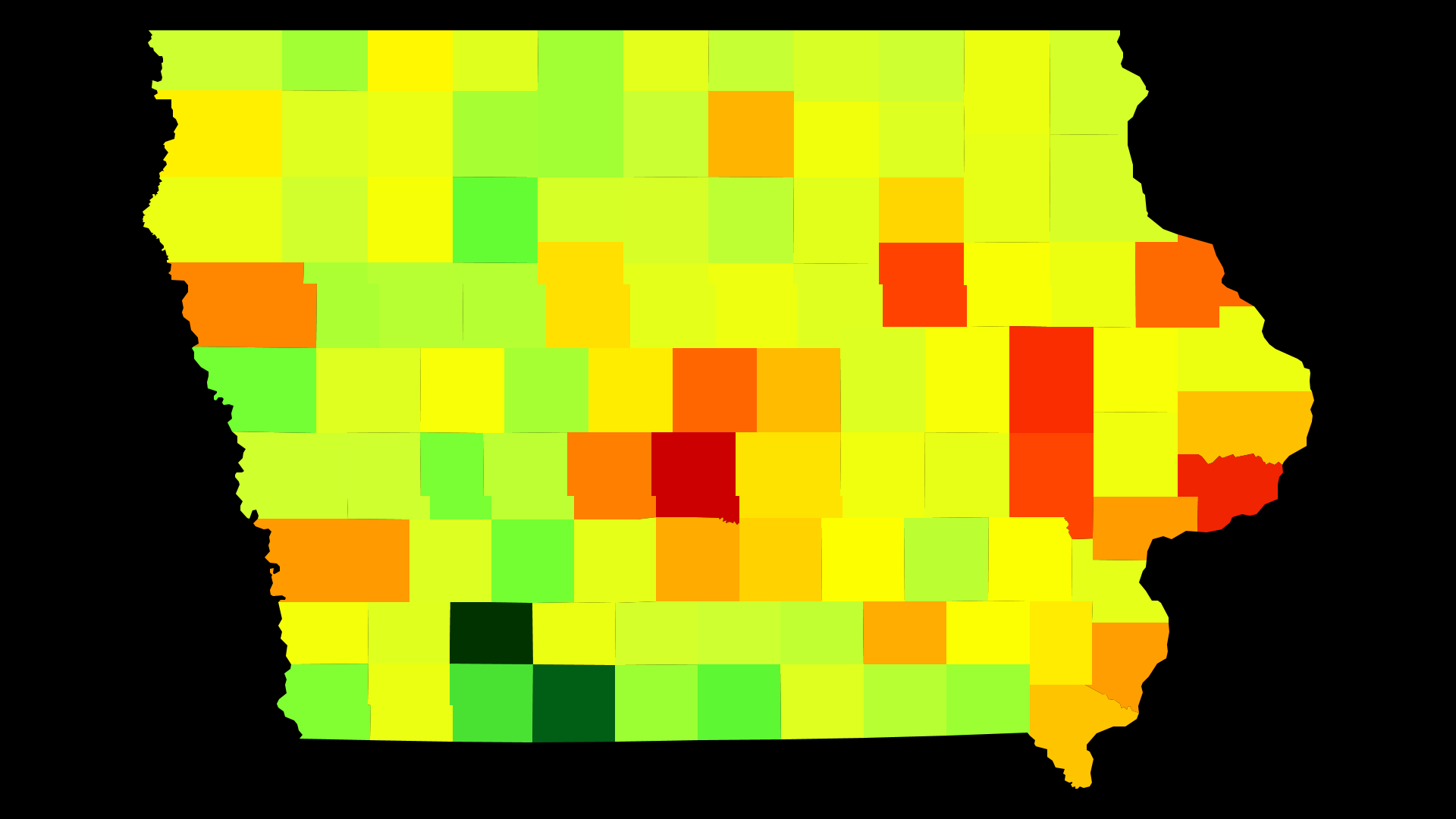
Iowa Population Density by County
| County | Population Density (Population/km2) | Population | Area (km2) |
|---|---|---|---|
| Polk County | 295 | 451,677 | 1,534 |
| Scott County | 140 | 170,385 | 1,217 |
| Linn County | 115 | 216,111 | 1,877 |
| Black Hawk County | 89 | 132,546 | 1,484 |
| Johnson County | 86 | 139,155 | 1,616 |
| Story County | 62 | 92,406 | 1,487 |
| Dubuque County | 60 | 95,697 | 1,595 |
| Dallas County | 49 | 74,641 | 1,534 |
| Woodbury County | 45 | 102,130 | 2,274 |
| Pottawattamie County | 37 | 92,728 | 2,478 |
| Muscatine County | 37 | 42,836 | 1,165 |
| Des Moines County | 36 | 40,480 | 1,114 |
| Warren County | 32 | 47,336 | 1,481 |
| Wapello County | 31 | 35,391 | 1,128 |
| Cerro Gordo County | 29 | 43,575 | 1,495 |
| Marshall County | 28 | 40,994 | 1,485 |
| Clinton County | 26 | 48,420 | 1,838 |
| Lee County | 26 | 35,682 | 1,397 |
| Marion County | 22 | 33,252 | 1,479 |
| Bremer County | 22 | 24,624 | 1,138 |
| Webster County | 20 | 37,044 | 1,862 |
| Jasper County | 19 | 36,641 | 1,899 |
| Henry County | 18 | 20,222 | 1,131 |
| Boone County | 18 | 26,364 | 1,488 |
| Sioux County | 17 | 34,547 | 1,999 |
| Dickinson County | 16 | 16,955 | 1,043 |
| Mahaska County | 15 | 22,417 | 1,484 |
| Washington County | 15 | 22,015 | 1,480 |
| Jefferson County | 15 | 16,810 | 1,133 |
| Buchanan County | 14 | 20,976 | 1,485 |
| Carroll County | 14 | 20,598 | 1,481 |
| Jones County | 14 | 20,611 | 1,490 |
| Benton County | 14 | 25,699 | 1,861 |
| Buena Vista County | 14 | 20,567 | 1,499 |
| Mills County | 13 | 14,896 | 1,137 |
| Floyd County | 12 | 16,092 | 1,299 |
| Poweshiek County | 12 | 18,601 | 1,518 |
| Cedar County | 12 | 18,393 | 1,507 |
| Hardin County | 12 | 17,441 | 1,476 |
| Winneshiek County | 12 | 20,994 | 1,796 |
| Delaware County | 12 | 17,534 | 1,501 |
| Jackson County | 12 | 19,587 | 1,683 |
| Union County | 11 | 12,583 | 1,107 |
| Page County | 11 | 15,713 | 1,384 |
| Plymouth County | 11 | 24,957 | 2,239 |
| Clay County | 11 | 16,491 | 1,481 |
| Fayette County | 11 | 20,502 | 1,901 |
| Iowa County | 11 | 16,330 | 1,525 |
| Madison County | 11 | 15,448 | 1,457 |
| Louisa County | 10 | 11,282 | 1,081 |
| Hamilton County | 10 | 15,312 | 1,496 |
| Winnebago County | 10 | 10,554 | 1,041 |
| Butler County | 10.0 | 15,021 | 1,507 |
| Emmet County | 9.6 | 9,996 | 1,042 |
| Montgomery County | 9.6 | 10,424 | 1,090 |
| Appanoose County | 9.5 | 12,692 | 1,335 |
| Grundy County | 9.5 | 12,314 | 1,300 |
| O'Brien County | 9.4 | 14,044 | 1,491 |
| Crawford County | 9.4 | 17,434 | 1,851 |
| Chickasaw County | 9.4 | 12,321 | 1,310 |
| Tama County | 9.4 | 17,576 | 1,870 |
| Cass County | 9.3 | 13,598 | 1,460 |
| Mitchell County | 8.8 | 10,709 | 1,217 |
| Clayton County | 8.7 | 17,773 | 2,052 |
| Wright County | 8.6 | 12,972 | 1,508 |
| Humboldt County | 8.5 | 9,688 | 1,136 |
| Clarke County | 8.4 | 9,325 | 1,116 |
| Allamakee County | 8.3 | 14,169 | 1,702 |
| Cherokee County | 8.0 | 11,945 | 1,495 |
| Harrison County | 8.0 | 14,431 | 1,814 |
| Shelby County | 7.8 | 11,961 | 1,528 |
| Lucas County | 7.8 | 8,746 | 1,124 |
| Howard County | 7.8 | 9,526 | 1,225 |
| Lyon County | 7.7 | 11,712 | 1,517 |
| Hancock County | 7.5 | 11,094 | 1,484 |
| Worth County | 7.3 | 7,541 | 1,035 |
| Monroe County | 7.1 | 8,012 | 1,130 |
| Franklin County | 7.0 | 10,548 | 1,509 |
| Guthrie County | 7.0 | 10,687 | 1,537 |
| Keokuk County | 6.9 | 10,329 | 1,504 |
| Sac County | 6.7 | 10,071 | 1,495 |
| Davis County | 6.7 | 8,791 | 1,307 |
| Calhoun County | 6.7 | 9,926 | 1,481 |
| Ida County | 6.4 | 7,141 | 1,121 |
| Palo Alto County | 6.2 | 9,185 | 1,480 |
| Greene County | 6.2 | 9,139 | 1,482 |
| Kossuth County | 6.0 | 15,321 | 2,534 |
| Osceola County | 6.0 | 6,211 | 1,031 |
| Decatur County | 5.9 | 8,136 | 1,383 |
| Van Buren County | 5.9 | 7,436 | 1,267 |
| Fremont County | 5.3 | 7,080 | 1,341 |
| Audubon County | 5.1 | 5,873 | 1,146 |
| Adair County | 5.0 | 7,472 | 1,483 |
| Monona County | 5.0 | 9,121 | 1,814 |
| Pocahontas County | 4.8 | 7,154 | 1,496 |
| Wayne County | 4.7 | 6,402 | 1,364 |
| Taylor County | 4.4 | 6,161 | 1,388 |
| Ringgold County | 3.6 | 5,072 | 1,393 |
| Adams County | 3.5 | 3,894 | 1,099 |
Comments
© 2018 AtlasBig.com