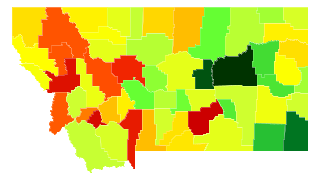
Montana Population Density
Montana Population Density Map
Montana Population Density by County
| County | Population Density (Population/km2) | Population | Area (km2) |
|---|---|---|---|
| Yellowstone County | 22 | 154,162 | 6,856 |
| Silver Bow County | 19 | 34,523 | 1,863 |
| Missoula County | 16 | 111,807 | 6,779 |
| Gallatin County | 14 | 94,720 | 6,837 |
| Cascade County | 12 | 82,384 | 7,028 |
| Lewis and Clark County | 7.2 | 65,338 | 9,064 |
| Flathead County | 6.8 | 93,068 | 13,611 |
| Lake County | 6.8 | 29,017 | 4,289 |
| Ravalli County | 6.6 | 40,823 | 6,221 |
| Deer Lodge County | 4.9 | 9,329 | 1,920 |
| Jefferson County | 2.7 | 11,512 | 4,298 |
| Hill County | 2.2 | 16,568 | 7,552 |
| Park County | 2.2 | 15,682 | 7,255 |
| Richland County | 2.1 | 11,214 | 5,444 |
| Lincoln County | 2.0 | 19,460 | 9,518 |
| Stillwater County | 2.0 | 9,318 | 4,682 |
| Carbon County | 1.9 | 10,340 | 5,347 |
| Roosevelt County | 1.8 | 11,125 | 6,137 |
| Broadwater County | 1.8 | 5,692 | 3,206 |
| Glacier County | 1.7 | 13,739 | 7,879 |
| Sanders County | 1.6 | 11,363 | 7,218 |
| Dawson County | 1.5 | 9,445 | 6,172 |
| Pondera County | 1.5 | 6,211 | 4,241 |
| Mineral County | 1.3 | 4,275 | 3,170 |
| Custer County | 1.2 | 11,951 | 9,821 |
| Powell County | 1.2 | 6,993 | 6,051 |
| Teton County | 1.0 | 6,065 | 5,944 |
| Fergus County | 1.0 | 11,501 | 11,276 |
| Toole County | 1.0 | 5,138 | 5,049 |
| Big Horn County | 1.0 | 13,042 | 12,988 |
| Musselshell County | 0.95 | 4,629 | 4,857 |
| Sheridan County | 0.83 | 3,668 | 4,419 |
| Madison County | 0.83 | 7,712 | 9,332 |
| Sweet Grass County | 0.76 | 3,669 | 4,815 |
| Fallon County | 0.73 | 3,079 | 4,204 |
| Rosebud County | 0.72 | 9,329 | 13,031 |
| Granite County | 0.70 | 3,138 | 4,498 |
| Beaverhead County | 0.65 | 9,341 | 14,440 |
| Liberty County | 0.63 | 2,369 | 3,750 |
| Blaine County | 0.60 | 6,604 | 10,996 |
| Valley County | 0.58 | 7,630 | 13,126 |
| Wheatland County | 0.58 | 2,134 | 3,700 |
| Chouteau County | 0.57 | 5,849 | 10,343 |
| Daniels County | 0.49 | 1,791 | 3,684 |
| Wibaux County | 0.49 | 1,121 | 2,307 |
| Judith Basin County | 0.42 | 2,016 | 4,842 |
| Meagher County | 0.31 | 1,937 | 6,209 |
| Phillips County | 0.31 | 4,179 | 13,505 |
| Golden Valley County | 0.28 | 859 | 3,042 |
| Treasure County | 0.27 | 700 | 2,560 |
| Prairie County | 0.26 | 1,179 | 4,527 |
| McCone County | 0.25 | 1,709 | 6,964 |
| Powder River County | 0.20 | 1,748 | 8,545 |
| Carter County | 0.14 | 1,174 | 8,674 |
| Petroleum County | 0.12 | 506 | 4,341 |
| Garfield County | 0.10 | 1,290 | 12,561 |
Comments
© 2018 AtlasBig.com
