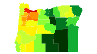
Oregon Population Density
Oregon Population Density Map
Oregon Population Density by County
| County | Population Density (Population/km2) | Population | Area (km2) |
|---|---|---|---|
| Multnomah County | 636 | 766,135 | 1,205 |
| Washington County | 295 | 554,996 | 1,882 |
| Marion County | 105 | 323,614 | 3,088 |
| Clackamas County | 80 | 388,263 | 4,882 |
| Yamhill County | 54 | 100,725 | 1,861 |
| Benton County | 49 | 86,591 | 1,760 |
| Polk County | 40 | 76,794 | 1,928 |
| Lane County | 30 | 356,212 | 11,968 |
| Jackson County | 29 | 208,545 | 7,258 |
| Columbia County | 28 | 49,344 | 1,752 |
| Deschutes County | 21 | 165,954 | 7,916 |
| Linn County | 20 | 118,765 | 5,981 |
| Josephine County | 20 | 83,306 | 4,254 |
| Lincoln County | 18 | 46,350 | 2,569 |
| Clatsop County | 17 | 37,244 | 2,157 |
| Hood River County | 16 | 22,675 | 1,382 |
| Coos County | 15 | 62,282 | 4,177 |
| Umatilla County | 9.1 | 76,720 | 8,388 |
| Tillamook County | 8.8 | 25,317 | 2,871 |
| Douglas County | 8.1 | 106,940 | 13,133 |
| Curry County | 5.3 | 22,339 | 4,237 |
| Union County | 4.9 | 25,652 | 5,282 |
| Jefferson County | 4.6 | 21,145 | 4,641 |
| Klamath County | 4.1 | 65,910 | 15,900 |
| Wasco County | 4.1 | 25,477 | 6,201 |
| Crook County | 2.7 | 20,815 | 7,740 |
| Morrow County | 2.1 | 11,336 | 5,293 |
| Baker County | 2.0 | 16,018 | 8,001 |
| Malheur County | 1.2 | 30,479 | 25,741 |
| Wallowa County | 0.83 | 6,814 | 8,167 |
| Sherman County | 0.80 | 1,731 | 2,153 |
| Grant County | 0.62 | 7,283 | 11,736 |
| Gilliam County | 0.61 | 1,947 | 3,168 |
| Lake County | 0.36 | 7,820 | 21,662 |
| Wheeler County | 0.31 | 1,381 | 4,445 |
| Harney County | 0.27 | 7,146 | 26,506 |
Comments
© 2018 AtlasBig.com
